
NOAA Announces Arrival Of El Niño, 2015 Poised To Beat 2014 For Hottest Year

The National Oceanic and Atmospheric Administration (NOAA) has announced that the long-awaited El Niño has arrived. NOAA’s Climate Prediction Center says we now have “borderline, weak El Niño conditions,” and there is a “50-60% chance that El Niño conditions will continue” through the summer.
An El Niño is “characterized by unusually warm ocean temperatures in the Equatorial Pacific,” as NOAA has explained. That contrasts with the unusually cold temps in the Equatorial Pacific during a La Niña. Both are associated with extreme weather around the globe (though a weak El Niño like this will tend to have a muted effect). El Niños tend to set the record for the hottest years, since the regional warming adds to the underlying global warming trend. La Niña years tend to be below the global warming trend line.
If even a weak El Niño does persist through summer, 2015 will almost certainly top 2014 as the hottest year on record. But there is a good chance it will do so in any case (unless a La Niña forms). After all, 2014 was the hottest year on record even though there was no official El Niño during the year. It’s just hard to stop the march of human-caused global warming — without actually sharply cutting greenhouse gas emissions.
Significantly, because 1998 was an unusually strong “super El Niño,” and because we haven’t had an El Niño since 2010, it appeared for a while (to some) as if global warming had slowed — if you cherry-picked a relatively recent start year (and ignored the rapid warming in the oceans, where 90 percent of human-caused planetary warming goes). In fact, however, several recent studies confirmed that planetary warming continues apace everywhere you look.
And that was before 2014 set the record for the hottest year. In January, Gavin Schmidt, director of NASA’s Goddard Institute of Space Studies, tweeted, “Is there evidence that there is a significant change of trend from 1998? (Spoiler: No.)” He attached this chart:
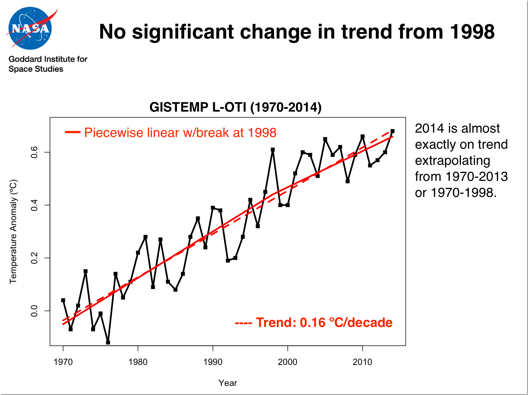
The latest NASA temperature data make clear that not only has there been no “pause” in surface temperature warming in the past decade and a half, there hasn’t even been a significant change in trend.
The very latest research suggests that we are about to enter a multiyear period of rapid warming. Fasten your seatbelts.
Related Posts
Tags
Share This


Follow Us!