
Do Urban Growth Boundaries Work?
Urban growth boundaries are held up as one of the most effective tools for limiting sprawl. But do they actually constrain unplanned development? Three urban growth boundaries — in Portland, Oregon; King County, Washington; and Denver, Colorado — were examined in a session at the American Planning Association (APA) conference in Seattle. A few interesting points came out of the discussion: growth boundaries are flexible and constantly being renegotiated. When they succeed, it’s because there is widespread political support for limiting growth and directing it to urban centers. Redevelopment and infill development in the cores relieve pressure on the outer boundaries, and offering incentives to those outside the boundary to limit development can work.
Portland’s Bipartisan Boundary Holds
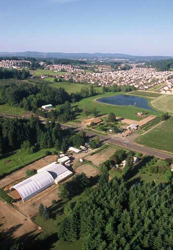
Ted Reid, a planner with Portland city government, explained how Oregon became the first state to adopt urban growth boundaries in 1973. “It was a rare moment of bipartisanship.” Governor Tom McCall, environmental groups, and farmers together persuaded legislators to pass Senate Bill 100, with the goal of protecting Oregon’s natural splendor from sprawl. Every community then had to develop its own long-range plan for managing growth, with Portland creating its urban growth boundary in 1979. Since then, the population of Portland has grown 60 percent, while the urban growth boundary has expanded just 14 percent.
The organizational structure to administer the growth boundary was deliberately set up to distribute powers among multiple players. There’s a metro planning organization, which is a land-use planning authority; an elected metro council; and three counties, with 25 cities within these units. Inside Portland’s boundary, there are 406 square miles, with 1.5 million people and 775,000 jobs. Outside the boundary, “there are 36 miles of urban reserve, which is suitable for further urbanization. If the area inside the boundary can’t reasonably accommodate development, the growth boundary can expand,” explained Reid. And it has expanded: 32,000 acres have been added, just in the 2000s. But then a 415-square-mile rural reserve around the city acts as a strict greenbelt to limit sprawl.
Portland’s 2040 growth concept designated urban centers, “where growth is supposed to happen.” And it has largely worked: “94 percent of growth has occurred in the original 1979-established zone. There has been tremendous activity in central Portland, with many changes in close-in locations.” For example, along North Mississippi Avenue, there was a complete overhaul in about 7 years, with transformational infill development. But, Reid also argued that some things have worked less well. Some of the tacked-on land that has expanded the boundary is still vacant. Land becomes open to development, but plans fall through. “Land readiness — not land supply — is our region’s biggest growth management challenge.”

Every 6 years, Portland does a “range forecast, looking out 20 years.” Reid admitted that “some expectations for the future will be wrong. Things can go sideways.” But as of now, Portland’s city government expects to add 400,000 people, 200,000 homes, and 300,000 jobs in the next 20 years. “We anticipate 76 of growth will be in likely redevelopment areas.” For now, Portland is not expanding its boundary.
King County’s Smart Use of Transfer Development Rights
King County’s urban growth boundary is not a straight line, it zigs and zags, explained Karen Wolff, a senior planner with the King County government, which includes Seattle and 38 other cities. The county is the 13th largest in the U.S., with 2 million people in 2,100 square miles. It has a 460 square mile growth area. In 1964, the area created its first comprehensive plan, and in 1990, there was a bipartisan agreement that led to the growth management act, which down-zoned two-thirds of the county from development areas to rural land, agriculture, and forests. In 2008, the county adopted Vision 2040, which “redefined the urban growth boundary and rewrote county planning policies. The county is now responsible for the urban growth boundary.”
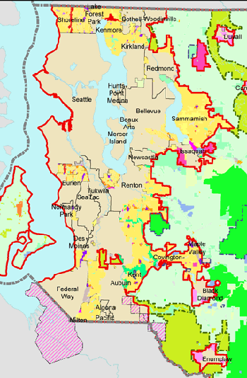
With the growth management act, there are now just three land uses — urban, rural, and resource. “No more suburban half-acre or 1-acre lots.” However, much of the pre-development suburbs were grandfathered in, and they continue in their current suburban form. From 1994 to 2004, there have been many changes to the urban growth boundary. “Some land was taken out of the boundary and turned into agricultural productivity areas,” while some areas that were designated rural have become urban parkland. To date, 98 percent of growth has been in the urban growth boundary though, with 86 percent in the cities. “We have maintained the acreage of the resource and rural lands.”
Like Portland, King County is directing development to urban centers. Cities decide how they are going to increase density. But “our green wall prevents expansion.” One way this green wall has held up is King County has allowed the transfer of development rights from rural areas to inside the growth boundary. This has provided some benefits to the farmers who wanted to redevelop their land. “It was a pressure release valve. Now there’s less demand to subdivide.” Farmers sell to the city center, creating a nexus, a relationship between the city and farms that has lasted. “Farmland is protected, the cities are a little denser, and now we have farmers markets.”

Wolff explained that King County’s success is rooted in widespread public concern about sprawl and local politicians who have listened, taking the “long view.” Geography has also helped — with bodies of water and mountains acting as natural boundaries. And preserving views of these natural wonders has also been a motivation. King County’s model has become the model for Washington State’s growth management act. But she added that “not everything is great: edge cities are looking to expand into green fields; there is growing pressure to expand from within the boundary out; and there are still some farmers who want to subdivide.”
Denver Uses Peer Pressure
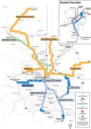
According to Andy Taylor, a senior planner with Denver Regional Council of Governments (DRCOG), explained how 9 counties have come together to create a 980-square-mile urban growth boundary. His group is an “advisory regional planner” that helps facilitate regional consensus. In the 1990s, Denver was facing “increased traffic, loss of open space, reduced water supply that put our quality of life at risk.” To respond, in 1995, a metro vision was created, with a set of key principles and preferred scenarios. In 1997, that resulted in Plan 2020, and a urban growth boundary. This boundary wasn’t “mandated by the state or federal government; its voluntary, bottom-up.” One place where the counties discuss how development should occur is through DRCOG, which is comprised of elected officials from member governments who award allocations for development. Member jurisdictions then decide on how they will use those allocations. Staff of this organization track changes.
In 1997, at the start of the boundary, the Denver regional area boundary was 700 square miles, but over the years it has continued to grow. By 2002, it was up to 750 square miles. Then, the base changed and it jumped up to 971 square miles by 2007. In 2009, it reached 980 square miles. Counties use a “flexible approach, and can self-certify changes.” While Denver’s boundary seems to just continue to expand unabated, Taylor argues that there are success: from 2006 to 2014, density has increased 7 percent and 770 square miles of open space around communities has been protected.
“Peer pressure has led to tangible results. Nobody wants to be seen as a bad actor.” Counties adhere to the principles, but there are massive changes coming to the area that may put pressure on this voluntary system. Apartment vacancy rates are already at just 4.7 percent. “There is low home inventory.” A 50-mile rail system is coming online. By 2016, most of these lines will open, resulting in a 150 percent increase in the rapid transit system and a 175 percent increase in dense, mixed-use urban development.
Denver plans to continue to focus development in the region’s urban centers, with a majority of new housing coming in there. But an already limited water supply — Denver gets just 15 inches of rain per year — means there are broader existential issues. “The erosion of the water supply is a roadblock for developers. It puts a limit on growth.”
Related Posts
Tags
Share This


Follow Us!